Escanaba Trough: Exploring the Seafloor and Oceanic Footprints

Past Expedition

Dates
May 26 - June 14, 2022
Location
Pacific Ocean

Overview

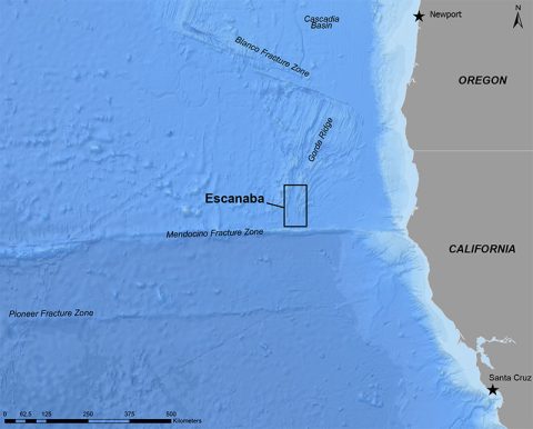
Between May 26 – June 14, 2022, a team of scientists explored Escanaba Trough, a feature located about 200 miles off the coast of northern California. Through remotely operated and autonomous underwater vehicle dives, they made several unexpected geological discoveries that will enhance our understanding of the hydrothermal sulfide system within the trough.

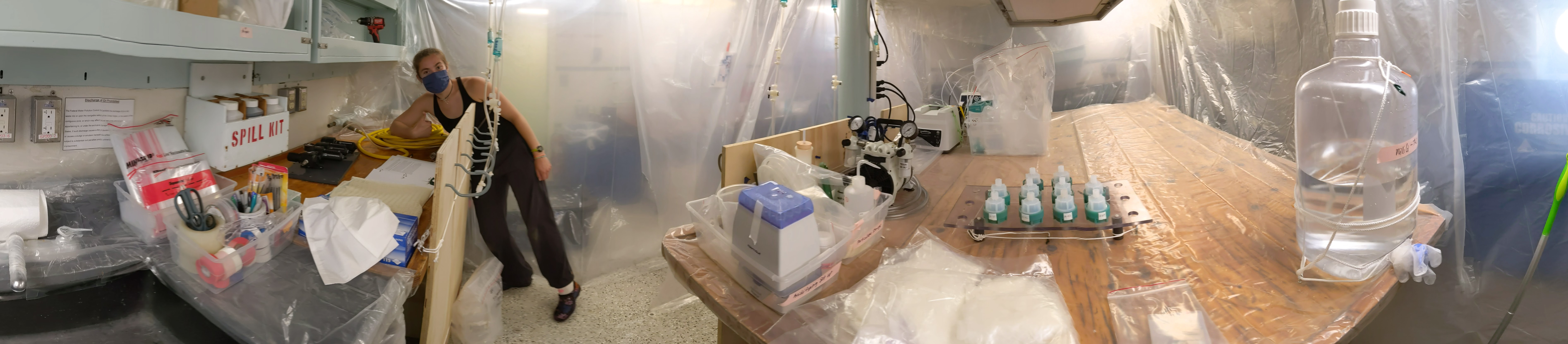
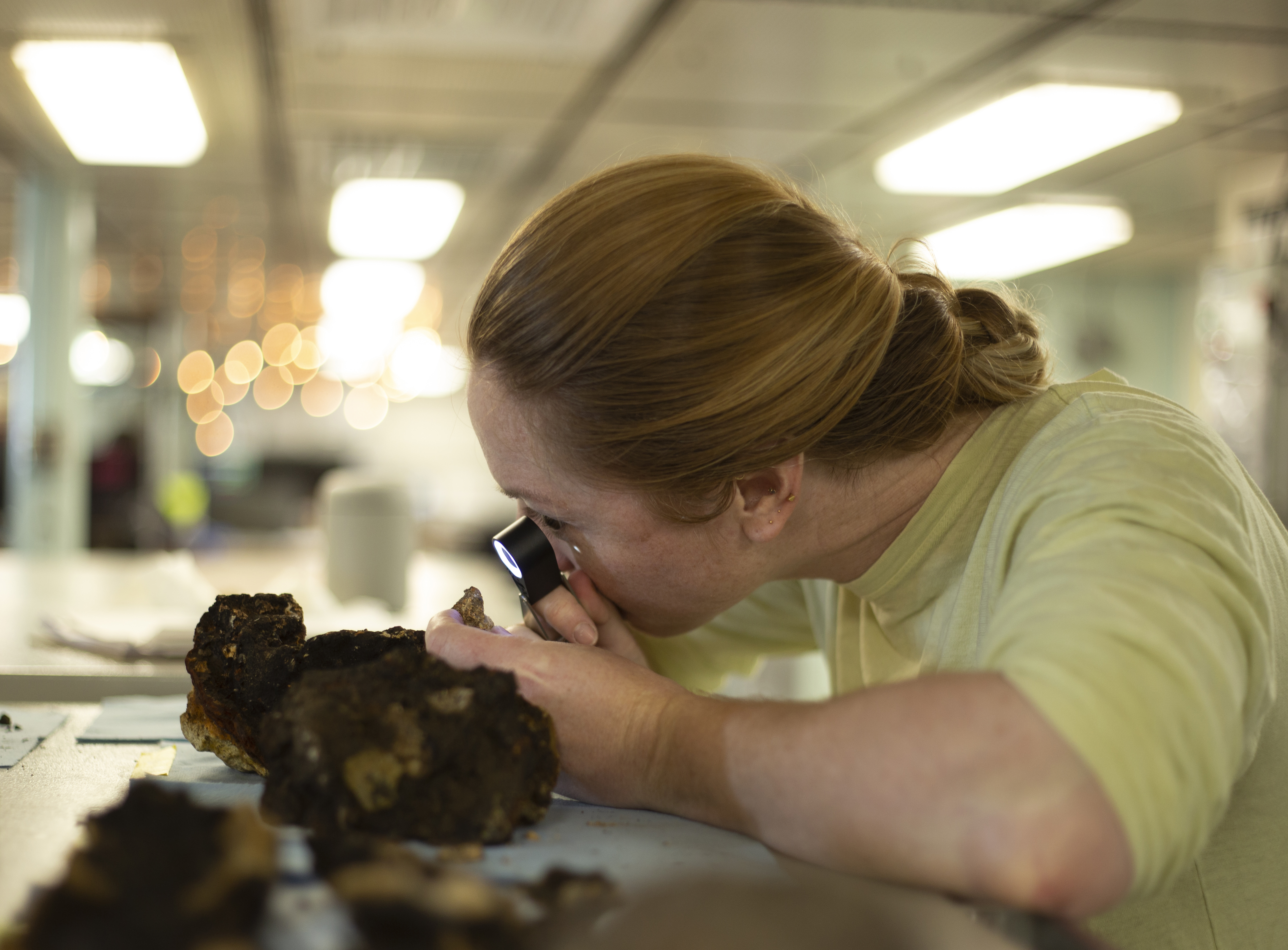
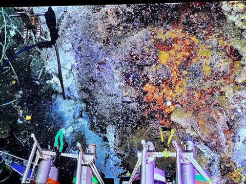
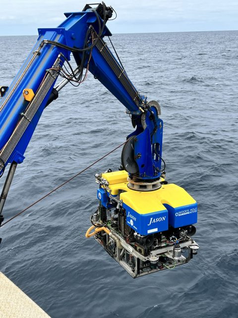
Over the course of the expedition, a total of 11 dives were conducted using Woods Hole Oceanographic Institution (WHOI)’s remotely operated vehicle (ROV) Jason, exploring at depths as great as 3,300 meters (2.05 miles). Extensive geologic, geochemical, and biological samples were collected using ROV Jason, including 65 rocks, 41 discrete biological specimens, 101 push cores, and 6 hydrothermal vent fluid samples collected in titanium alloy gas-tight bottles. These gas-tight fluid samples will be analyzed for their gas and liquid composition by scientists with the NOAA Pacific Marine Environmental Laboratory (PMEL) to get more information about the source of the venting fluids and their subseafloor interactions with rocks and sediments.

The team also conducted 12 CTD (conductivity, temperature, and depth) casts and collected 388 water samples for further analysis. The NOAA team will be analyzing water samples from both CTD and ROV Jason Niskins bottles for gasses, trace metals, and metal-binding organic ligands. Additional water samples were collected by other scientists on board to investigate radionuclides to date the water samples and genomic studies to understand what organisms are present in active and inactive sites.

Laura Moore, a doctoral candidate at the University of Washington School of Oceanography, in the trace metal clean bubble to process water samples from the CTD and remotely operated vehicle Jason during the Escanaba Trough: Exploring the Seafloor and Oceanic Footprints expedition.
Laura Moore, a doctoral candidate at the University of Washington School of Oceanography, in the trace metal clean bubble to process water samples from the CTD and remotely operated vehicle Jason during the Escanaba Trough: Exploring the Seafloor and Oceanic Footprints expedition. Image courtesy of Escanaba Trough: Exploring the Seafloor and Oceanic Footprints.
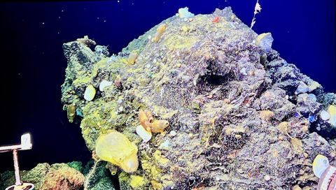
Download largest version (jpg, 3.2 MB).

Additionally, 10 dives were completed using WHOI’s autonomous underwater vehicle (AUV) Sentry, allowing for the testing of new seafloor mapping techniques using the vehicle.

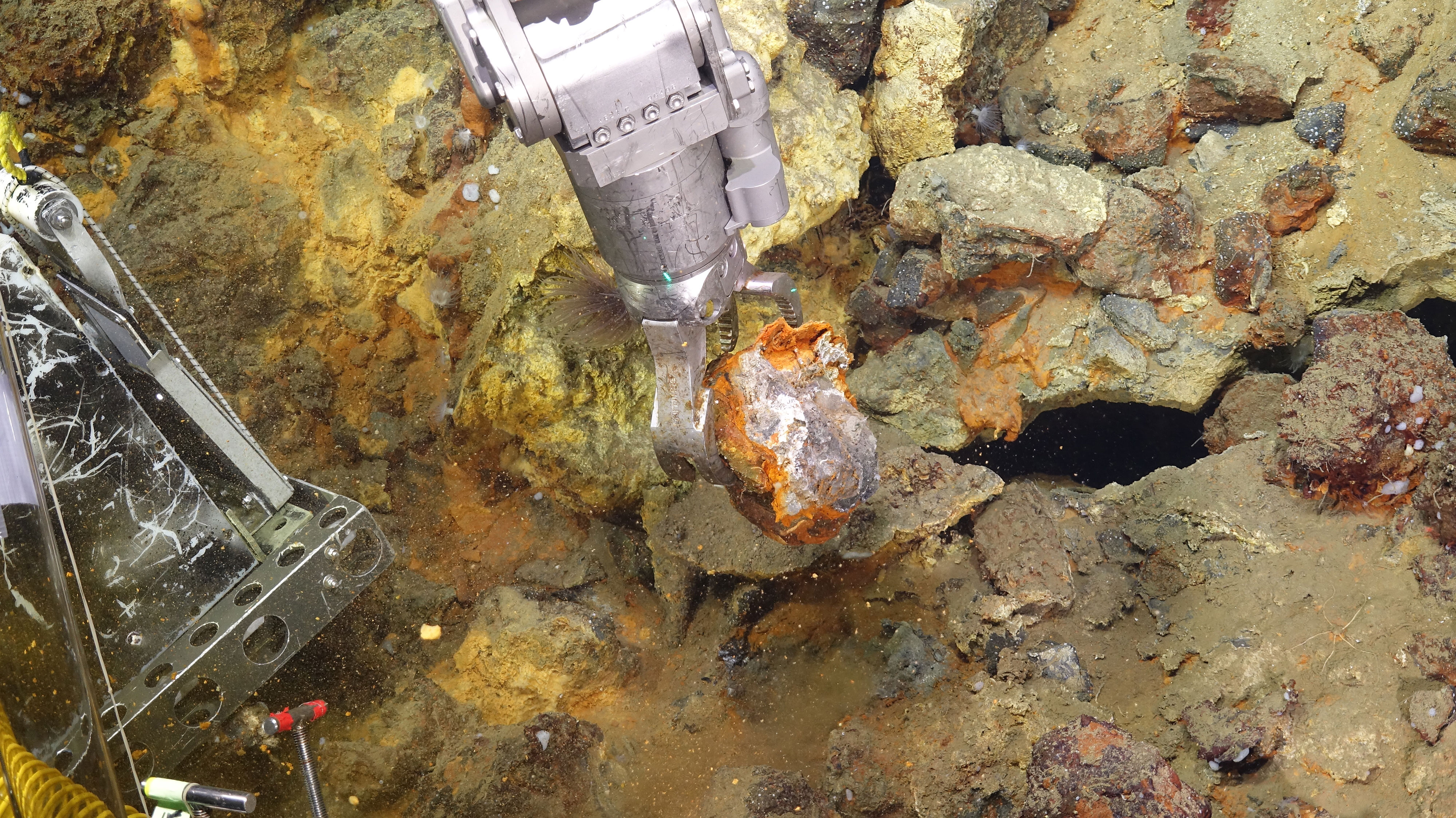
Initial findings from the expedition included hydrothermal activity in a region that was previously considered to be inactive and the discovery of unexpected volcanic features and pockmarks. Miniature Autonomous Plume Recorders from NOAA PMEL were deployed on ROV Jason and AUV Sentry to detect particle, temperature, and oxidation/reduction potential (ORP) anomalies. ORP anomalies, which can be excellent indicators of hydrothermal activity and fluid flow, were detected in 3 out of 10 AUV Sentry dives and on all ROV Jason dives.

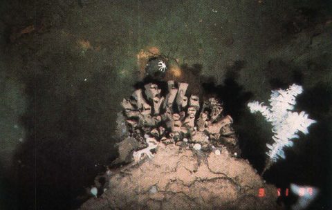
The team also found several occurrences of inactive sulfide minerals as well as hydrothermal minerals in unexpected places.

Visit the U.S. Geological Survey expedition page to learn more.

View the initial Expedition Overview.

Amy Gartman, U.S. Geological Survey Research Oceanographer and chief scientist for the Escanaba Trough expedition, examines a mineral sample with a hand lens aboard Research Vessel Thomas G. Thompson during the Escanaba Trough: Exploring the Seafloor and Oceanic Footprints expedition.
Amy Gartman, U.S. Geological Survey Research Oceanographer and chief scientist for the Escanaba Trough expedition, examines a mineral sample with a hand lens aboard Research Vessel Thomas G. Thompson during the Escanaba Trough: Exploring the Seafloor and Oceanic Footprints expedition. Image courtesy of U.S. Geological Survey.
Download largest version (jpg, 7 MB).
Woods Hole Oceanographic Institute's remotely operated vehicle Jason gathers a mineral sample from the seafloor at Escanaba Trough during the Escanaba Trough: Exploring the Seafloor and Oceanic Footprints expedition.
Woods Hole Oceanographic Institute’s remotely operated vehicle Jason gathers a mineral sample from the seafloor at Escanaba Trough during the Escanaba Trough: Exploring the Seafloor and Oceanic Footprints expedition. Image courtesy of Escanaba Trough: Exploring the Seafloor and Oceanic Footprints.
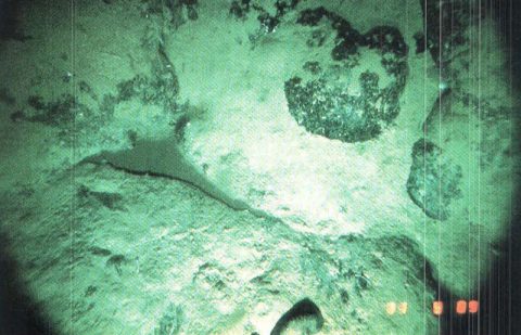
Download largest version (jpg, 5.3 MB).

Features

Research Vessel Thomas G. Thompson approaches the dock in Newport, Oregon, marking the end of the Escanaba Trough: Exploring the Seafloor and Oceanic Footprints expedition.
This highly-successful expedition is drawing to a close. Once all the equipment was back on the deck of Research Vessel Thomas G. Thompson, we began packing the labs as the ship journeyed back to Newport, Oregon.
June 15, 2022
Sponges and other organisms cover an outcrop observed on the northern portion of the Escanaba Trough during the Escanaba Trough: Exploring the Seafloor and Oceanic Footprints expedition.
During one of our last dives at the northern portion of the Escanaba Trough (“NESCA”), as we traveled across a mud flat towards another hydrothermal area.
June 8, 2022
An outcrop of hydrothermal rocks that presents colorful red and yellow tones from the iron sulfide under the outer layer of organic and sedimentary debris. Imaged during an Escanaba Trough: Exploring the Seafloor and Oceanic Footprints expedition dive with remotely operated vehicle Jason.
We’ve collected several more sets of water samples, gravity cores, and had a couple more joint autonomous underwater vehicle (AUV) Sentry and remote operated vehicle (ROV) Jason deployments. All the work through tomorrow is taking place in the northern section of the Escanaba study area, nicknamed “NESCA.”
June 5, 2022
View More View Less
Photo from expedition to Escanaba Trough in late 1980s of glassy, fresh pillow basalt flow at NESCA site.
scanaba Trough is the southern-most segment of the Gorda Ridge seafloor spreading center, the only mid-ocean ridge located within the US Exclusive Economic Zone.
June 3, 2022
Photo from expedition to Escanaba Trough in late 1980s of older, oxidized sulfide deposit colonized by sponges at SESCA site.
Hydrothermal systems occur when seawater percolates down through fractures in the oceanic crust, heating up as it nears the earth’s hot interior. These systems are often found near mid-ocean ridges such as Escanaba Trough, where tectonic plates diverge, and new seafloor is created.
June 3, 2022
Remotely operated vehicle Jason being deployed from the first dive of the Escanaba Trough: Exploring the Seafloor and Oceanic Footprints expedition.
The surveys conducted during this expedition will not only allow researchers to document and inventory the sites of lost submerged B-29 aircraft, but will also provide data for the potential discovery of additional archaeological sites, allow the stories of men who lost their lives to be remembered and shared, and advance deepwater archaeology from a technological/engineering perspective.
June 1, 2022
Map showing the location of the Escanaba Trough off the coast of California, the area targeted for exploration during the Escanaba Trough: Exploring the Seafloor and Oceanic Footprints expedition.
Between May 26 - June 14, 2022, a team of scientists will explore Escanaba Trough, about 200 miles off the coast of northern California, in order to characterize the hydrothermal sulfide system within the trough.
May 26, 2022

Multimedia

Featured multimedia assets associated with this project.

Education

Our Learn & Discover page provides the best of what the NOAA Ocean Exploration website has to offer to support educators in the classroom during this expedition. Each theme page includes expedition features, lessons, multimedia, career information, and associated past expeditions. Below are related top education themes for this expedition.

Meet the Exploration Team

Learn more about the team members and their contributions to this project.

Principal Investigator; Research Oceanographer, U.S. Geological Survey Pacific Coastal and Marine Science Center
Co-Principal Investigator, Emeritus Professor of Geology, University of California - Davis
Physical Scientist, Pacific Marine Lab, U.S. Geological Survey
Marine Facility, U.S. Geological Survey Pacific Coastal and Marine Science Center
Co-Principal Investigator, Research Benthic Ecologist, Wetland and Aquatic Research Center, U.S. Geological Survey
Physical Scientist, Global Marine Mineral Resources, U.S. Geological Survey

Resources & Contacts