2019 Technology Demonstration
Past Expedition
Overview
by Michael White, NOAA Office of Ocean Exploration and Research
July 18 – August 1, 2019
Download mission fact sheet (pdf, 5.2 MB).

Map showing the approximate route of NOAA Ship Okeanos Explorer during the two legs of the 2019 Technology Demonstration and current publicly available multibeam bathymetry data. Image courtesy of the NOAA Office of Ocean Exploration and Research, 2019 Technology Demonstration. Download image (jpg, 629 KB).
From July 18 to August 1, 2019, NOAA and partners will conduct a telepresence-enabled expedition on NOAA Ship Okeanos Explorer to demonstrate, test, and evaluate five emerging and existing technologies for possible integration into NOAA operations. New technologies and novel integrations such as those being tested during this mission will aid and accelerate the fulfillment of the NOAA Office of Ocean Exploration and Research (OER) objective to map and characterize the U.S. Exclusive Economic Zone by 2030. 2019 Technology Demonstration operations will also include mapping and remotely operated vehicle (ROV) dives. The expedition, which will take place off the U.S. East Coast, from Virginia to Rhode Island, will be broken into two legs.
Leg 1: July 18 – July 24
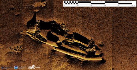
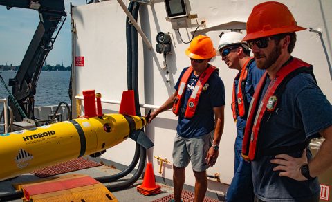
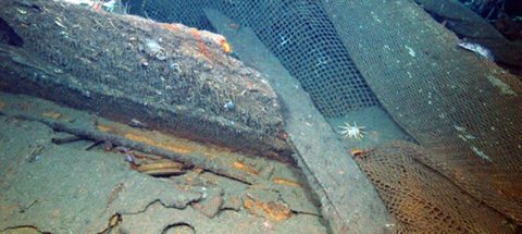
Leg 1 operations will include the deployment of a REMUS 600 Autonomous Underwater Vehicle (AUV) in partnership with the NOAA Office of Coast Survey (OCS) and a towed Kraken Robotics KATFISH™ with Synthetic Aperture Sonar in partnership with Kraken Robotics and ThayerMahan, Inc. Targets for testing these systems will focus on the U.S. northeast continental shelf and will include areas with limited bathymetric coverage, Underwater Cultural Heritage sites (UCH), and sites that were identified in the 2013 NOAA report, “Risk Assessment for Potentially Polluting Wrecks in U.S. Waters” . These systems will be deployed in concert with the Okeanos Explorer‘s suite of deepwater mapping systems.
Leg 2: July 25 – August 1
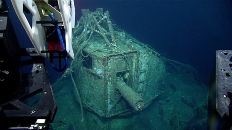
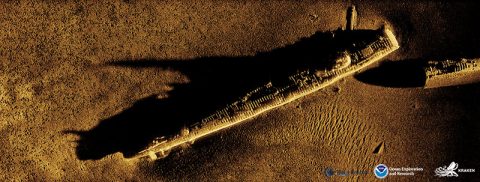
During Leg 2, we will test the integration of three technologies with OER’s ROV Deep Discoverer. These technologies include a 360-degree camera being developed at the Massachusetts Institute of Technology, a One-Way Travel-Time Inverted Ultra-Short Baseline navigation system from the Woods Hole Oceanographic Institution, and a Kraken Robotics SeaVision® laser scanner. ROV dives will target deepwater coral and sponge communities and a UCH target that is potentially the USS Baldwin, a U.S. Navy destroyer active during World War II that was intentionally scuttled on June 6, 1961. ROV dives will take place off the coasts of New York, Rhode Island, and Massachusetts.

NOAA Ship Okeanos Explorer in port in Norfolk, Virginia, following the completion of the Windows to the Deep 2019 expedition. Image courtesy of the NOAA Office of Ocean Exploration and Research, Windows to the Deep 2019. Download image (jpg, 3.2 MB).
Objectives
The primary objectives of this demonstration are to test, integrate, and evaluate emerging and existing technologies for potential use in meeting the data requirements of OER, its partners, and the larger oceanographic research community. The secondary objective of this demonstration is to provide authoritative and actionable data to regional stakeholders. Finally, this demonstration will contribute to NOAA’s Atlantic Seafloor Partnership for Integrated Research and Exploration (ASPIRE) campaign. ASPIRE is a collaborative, multinational field campaign that provides publicly accessible baseline data to increase our understanding of the North Atlantic Ocean and data critical to emerging blue economy priorities, characterization, and management.
Onboard Team
The team onboard the Okeanos Explorer will include personnel from ThayerMahan, Inc. , Kraken Robotics , the Massachusetts Institute of Technology , Woods Hole Oceanographic Institution , the NOAA Office of Coast Survey, the University of New Hampshire/Center for Coastal and Ocean Mapping , the University of Rhode Island , the NOAA Office of Marine and Aviation Operations Unmanned Aircraft Systems group, and NOAA’s National Centers for Environmental Information. Engineers from the Global Foundation for Ocean Exploration will facilitate data management, ROV integration and operations, and ship-to-shore communications. The expedition will be led onboard by the NOAA Office of Ocean Exploration and Research.
Technologies Being Demonstrated

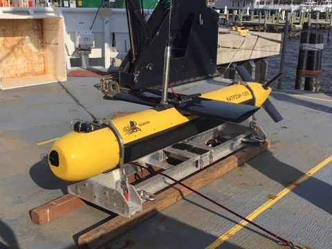
The REMUS 600 AUV staged on the Okeanos Explorer’s CTD deck while the ship is docked at NOAA Marine Operations Center – Atlantic in Norfolk. Image courtesy of the NOAA Office of Ocean Exploration and Research, 2019 Technology Demonstration. Download image (jpg, 10.4 MB).
The five instruments described below will be tested on the Okeanos Explorer during the 2019 Technology Demonstration. These technologies were selected given their potential to contribute to OER’s mapping and characterization goals while building a greater overall scientific understanding of our deep ocean.
REMUS 600 Autonomous Underwater Vehicle
Autonomous underwater vehicles (AUVs) will become increasingly integral to achieving OER mapping and characterization goals, acting as a force multiplier during mapping and ROV operations, particularly given the ability for multiple units to work in concert. OER will work with OCS to test operations on the OCS-owned REMUS 600 AUV, which is equipped with an EM 3002 multibeam sonar system that allows for high-resolution mapping. The testing of this commercial AUV will allow OER and partners to better understand the launch and recovery process, the acquisition and processing of AUV data, staffing and storage needs, as well as how AUV operations might fit into current Okeanos Explorer mapping and ROV exploration.
Kraken Active Towfish (KATFISH™) with Synthetic Aperture Sonar
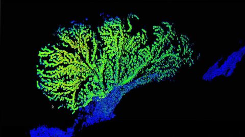
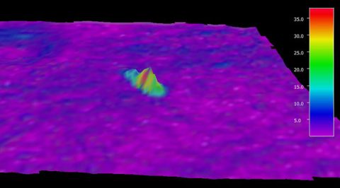
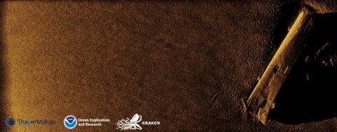
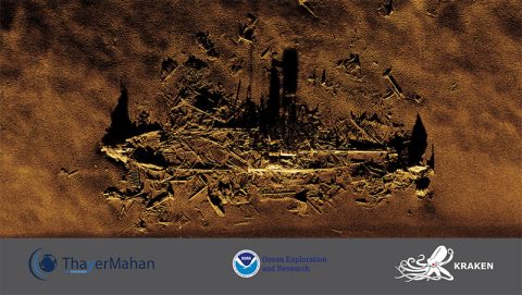
In 2018, OER and Kraken Underwater Systems began a partnership to jointly advance ocean exploration imaging technology. In the spirit of this collaboration, the 2019 Technology Demonstration will serve as an opportunity to test the Kraken towed KATFISH™ with Synthetic Aperture Sonar (SAS) on the Okeanos Explorer. KATFISH™ operates at shallower depths (less than 300 meters/984 feet) than current instruments on the Okeanos Explorer, giving it the potential to fill a gap in depth data identified by OER and partners. The KATFISH™ system is comprised of an actively controlled smart towfish, SAS imaging, bathymetry and gap-filler sonars, launch and recovery system, operator console, and visualization software. The system collects 3D bathymetry and ultra-high-resolution seabed imagery, providing detailed images of the seafloor and objects on it with 30 times more detail than a conventional side scan sonar.
‘Maka’oi’ 360-degree Camera
The Massachusetts Institute of Technology has developed a 360-degree camera that will be mounted on ROV Deep Discoverer and collect footage during Leg 2 2019 Technology Demonstration dives. The system is comprised of six compact 4K studio cameras housed within a spherical aluminum/titanium unit. The housing is currently rated to a depth of 4,000 meters (13,123 feet), but is designed to tolerate up to 4,500 meters (14,764 feet) with a wide safety margin. The camera operator will be able to view footage in real time and adjust each camera individually or in groups. The proximate goal is the creation of studio-caliber 360-degree video from the deep for virtual reality, augmented reality, documentary, and planetarium release. More experimentally, the ultimate goal is on-ship stitching of the video, giving the operator a real-time, live, 360-degree view from the ROV.
Kraken SeaVision® System
One objective of the NOAA-Kraken partnership is to test the SeaVision® laser line scanning system at deep-ocean depths. The SeaVision® laser scanner uses a line of laser light to generate high-resolution, 3D representations of objects on the seafloor, including biological and archaeological targets. Unlike traditional black and white scans, SeaVision® brings subsea laser imaging into vivid, full color. Practical applications include precise measurements of benthic organisms in order to accurately estimate the age and growth rates of these organisms and highly accurate measurements of percentage of benthic cover, one of the most frequently reported metrics in marine ecological studies.
One-Way Travel-Time Inverted Ultra-Short Baseline Navigation System
This navigation system is in development at the Woods Hole Oceanographic Institution to support multi-AUV navigation capability. This work leverages a National Science Foundation grant and builds upon a project supported through OER’s Federally Funded Opportunity. The aim is to develop a low-power acoustic navigation system for application with an array of autonomous vehicles. The system provides a single acoustic source that can be used for the navigation of multiple subsea vehicles, with no time or frequency sharing required. Three separate dives at a variety of depths will be conducted to test this technology, which will be mounted on ROV Deep Discoverer.

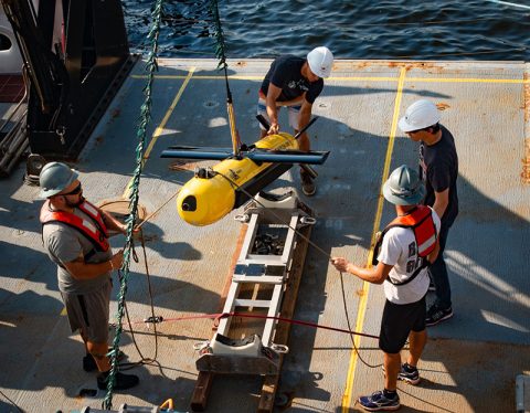
Operations personnel from ThayerMahan, Inc. and Kraken Robotics integrating the KATFISH™ on the back deck of the Okeanos Explorer. Image courtesy of the NOAA Office of Ocean Exploration and Research, 2019 Technology Demonstration. Download image (jpg, 4.2 MB).
Why It Matters
The 2019 Technology Demonstration will enable OER and partners to develop additional methods of exploration, refine and improve existing operations, and evaluate how new data types can improve baseline observations and seafloor characterization. By leading national efforts to explore our ocean, and by making ocean exploration more accessible, OER is filling gaps in the basic understanding of U.S. deep waters and seafloor and providing critical deep-ocean data needed to sustain and accelerate the economy, health, and security of our nation. Using the latest tools and technologies, such as those being demonstrated on this expedition, OER explores previously unknown areas of our deep ocean to make valuable scientific, economic, and cultural discoveries.
Follow Live
Anyone with an internet connection can follow along with the demonstration as video is streamed live to shore. Additional information will be available on OceanExplorer.NOAA.gov throughout the demonstration.

During the 2019 Technology Demonstration, several technologies will be mounted to ROV Deep Discoverer for testing and evaluation. Image courtesy of the NOAA Office of Ocean Exploration and Research, Windows to the Deep 2019. Download image (jpg, 2.8 MB).
Features
View Less
Multimedia
Featured multimedia assets associated with this project.
Education
Our Learn & Discover page provides the best of what the NOAA Ocean Exploration website has to offer to support educators in the classroom during this expedition. Each theme page includes expedition features, lessons, multimedia, career information, and associated past expeditions. Below are related top education themes for this expedition.
Meet the Exploration Team
Learn more about the team members and their contributions to this project.


Global Foundation for Ocean Exploration