2022 ROV and Mapping Shakedown

Past Expedition

Dates
February 23 - March 3, 2022
Location
Gulf of Mexico/Caribbean
Vessel
NOAA Ship Okeanos Explorer

Expedition Summary

February 23-March 3, 2022, NOAA Ocean Exploration led an expedition in the Gulf of Mexico and the western Straits of Florida to “shake down” the mission and related systems on NOAA Ship Okeanos Explorer.

The primary purpose of the shakedown was to ensure that the remotely operated vehicle (ROV), mapping, telepresence, positioning, and other important systems needed to conduct scientific activities were working properly and prepared for the season ahead. While system testing and troubleshooting took priority, we can’t have a shakedown without some degree of ocean exploration, which helps us better understand the deepwater areas of the region.

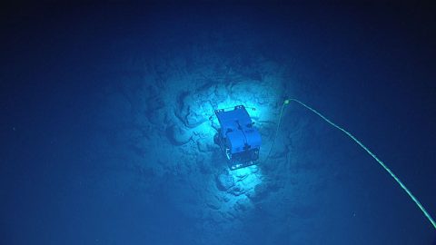
ROV testing and operations consisted of seven dives using the dual-bodied ROV system of Deep Discoverer and Seirios. Dives ranged in depth from 490 to 3,420 meters (1,608 to 11,220 feet). During these dives, ROV engineers tested Deep Discoverer’s existing electronic, hydraulic, lighting, and camera systems.

Shakedowns are also a good time to test new tools and technologies. This year, for example, we successfully piloted Deep Discoverer from shore in Rhode Island and tested a low-light camera with a tool to stimulate bioluminescence (picture Deep Discoverer holding a tennis racket) that allowed us to observe the production of light by corals and organisms in the water column.

Engineers on deck prepare remotely operated vehicle Deep Discoverer for a dive during the 2022 ROV and Mapping Shakedown with the new “bioluminescence agitator” that was built to stimulate light production by animals in the deep, dark ocean.
Engineers on deck prepare remotely operated vehicle Deep Discoverer for a dive during the 2022 ROV and Mapping Shakedown with the new “bioluminescence agitator” that was built to stimulate light production by animals in the deep, dark ocean. Image courtesy of Art Howard, GFOE, 2022.
Download largest version (jpg, 9.2 MB).
During shakedown expeditions, we also test our sampling capabilities and processes. At the request of a scientist on shore, we collected this jellyfish (Solmissus sp.) during Dive 05 of the 2022 ROV and Mapping Shakedown with the hopes of learning more about it.
During shakedown expeditions, we also test our sampling capabilities and processes. At the request of a scientist on shore, we collected this jellyfish (Solmissus sp.) during Dive 05 of the 2022 ROV and Mapping Shakedown with the hopes of learning more about it. Image courtesy of NOAA Ocean Exploration, 2022 ROV and Mapping Shakedown.
Download largest version (jpg, 1.1 MB).

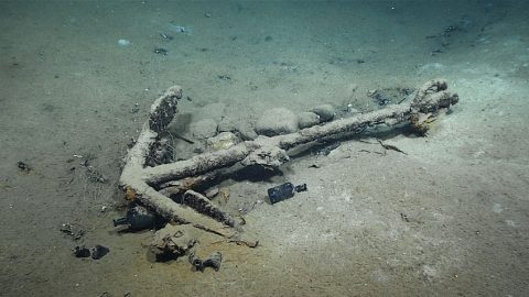
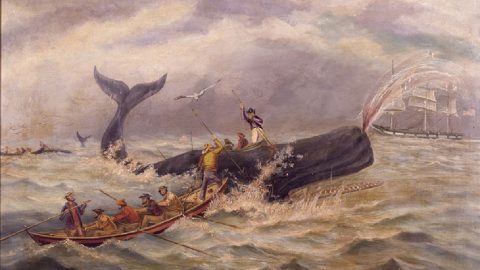
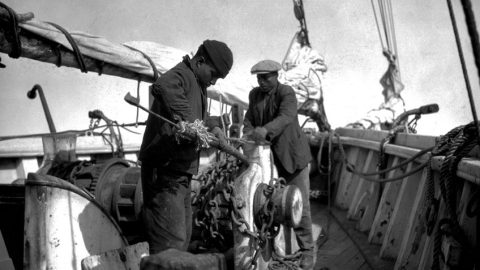
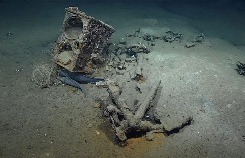
Also, while testing our new BlueView sonar, which helps ROV pilots detect objects and features before light from the ROV reaches them, we targeted a site on the seafloor at a depth of 1,830 meters (6,004 feet) that was believed to be a shipwreck. The test was another success. With video from the dive and extensive research, scientists confirmed that the wreck is likely the historically significant 19th century whaler Industry.

Extracted from a 3D model of the Industry shipwreck site explored during Dive 02 of the 2022 ROV and Mapping Shakedown, this photomosaic shows the ship’s remains and its outline in the sediment.
Extracted from a 3D model of the Industry shipwreck site explored during Dive 02 of the 2022 ROV and Mapping Shakedown, this photomosaic shows the ship’s remains and its outline in the sediment. Image courtesy of the Bureau of Ocean Energy Management using NOAA Ocean Exploration, 2022 ROV and Mapping Shakedown remotely operated vehicle video footage.
Download largest version (jpg, 12.7 MB).
The final dive (Dive 07) of the 2022 ROV and Mapping Shakedown was on a coral wonderland. The biodiversity was quite high and included corals, sponges, crinoids, brittle stars, squat lobsters, sea stars, anemones, shrimp, urchins, and more.
The final dive (Dive 07) of the 2022 ROV and Mapping Shakedown was on a coral wonderland. The biodiversity was quite high and included corals, sponges, crinoids, brittle stars, squat lobsters, sea stars, anemones, shrimp, urchins, and more. Image courtesy of NOAA Ocean Exploration, 2022 ROV and Mapping Shakedown.
Download largest version (jpg, 1.2 MB).

Other exploration highlights included the collection of 12 samples (3 geological and 3 biological; 6 water for environmental DNA analysis), the observation of a rich biodiversity of corals and sponges in a coral garden-like environment, and the first sighting of a candelabra octocoral in the Gulf of Mexico.

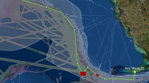
Since ocean exploration depends on accurate mapping data, we adjusted the multibeam sonar system for maximum accuracy and tested and assessed its readiness and the readiness of associated systems and equipment. In addition to the shakedown objectives, we mapped 4,926 square kilometers (1,902 square miles) and 829 linear kilometers (515 miles) of seafloor in areas deeper than 200 meters (656 feet), focusing on areas with no or low-quality mapping data.

View the initial Expedition Overview.

Operations

This map shows the mapping data collected (lines colored by depth) and remotely operated vehicle dive sites (green dots) for the 2022 ROV and Mapping Shakedown as completed.
This map shows the mapping data collected (lines colored by depth) and remotely operated vehicle dive sites (green dots) for the 2022 ROV and Mapping Shakedown as completed. Image courtesy of NOAA Ocean Exploration, 2022 ROV and Mapping Shakedown.
Download largest version (jpg, 2.6 MB).

Features

Remotely operated vehicle Deep Discoverer is skillfully piloted from shore over a boulder field in a canyon on the West Florida Shelf in the Straits of Florida during Dive 06 of the 2022 ROV and Mapping Shakedown.
During a recent expedition on NOAA Ship Okeanos Explorer, an engineer on shore, over a thousand miles away from the ship, successfully piloted a remotely operated vehicle (ROV) to explore the deep ocean. A first for NOAA Ocean Exploration and the Global Foundation for Ocean Exploration, this test of piloting an ROV from shore opens new possibilities for deep-ocean exploration.
May 4, 2022
On February 25, 2022, NOAA Ocean Exploration and partners from SEARCH Inc. and the Bureau of Ocean Energy Management discovered the remains of what is likely the brig Industry. This article below describes how the research team came to their conclusion.
March 23, 2022
On February 25, 2022, NOAA Ocean Exploration and partners from SEARCH Inc. and the Bureau of Ocean Energy Management discovered the remains of what is likely the brig Industry. This article below describes the whaling industry in the Gulf of Mexico around the time that Industry would have operated there.
March 23, 2022
View More View Less
On February 25, 2022, NOAA Ocean Exploration and partners from SEARCH Inc. and the Bureau of Ocean Energy Management discovered the remains of what is likely the brig Industry. This article describes Industry’s role in African-American and Indigenous people’s maritime history.
March 23, 2022
The artifacts shown here, including the tryworks and an anchor, helped confirm that the shipwreck explored during the February 25 dive is likely the remains of Industry, an historically significant 19th century whaler.
NOAA and partners today announced the discovery of the wreck of a 207-year-old whaling ship, called Industry, found on the bottom of the Gulf of Mexico.
March 23, 2022
On February 25, 2022, NOAA Ocean Exploration and partners from SEARCH Inc. and the Bureau of Ocean Energy Management discovered the remains of what is likely the brig Industry. This article below describes the whaling industry in the Gulf of Mexico around the time that Industry would have operated there.
February 23, 2022

Multimedia

Featured multimedia assets associated with this project.

Education

Our Learn & Discover page provides the best of what the NOAA Ocean Exploration website has to offer to support educators in the classroom during this expedition. Each theme page includes expedition features, lessons, multimedia, career information, and associated past expeditions. Below are related top education themes for this expedition.

Meet the Exploration Team

Learn more about the team members and their contributions to this project.

Expedition Coordinator, NOAA Ocean Exploration
Mapping Lead, NOAA Ocean Exploration
Mapping Expedition Coordinator in Training, NOAA Ocean Exploration
Internship Program Coordinator, NOAA Ocean Exploration
Engineering Intern, Global Foundation for Ocean Exploration
Video Editor, Global Foundation for Ocean Exploration

Expedition Data

Data collected during the expedition will be available in NOAA’s public data archives within 60-90 days of its completion and will be accessible via the NOAA Ocean Exploration Data Atlas.

Resources & Contacts

Media Contacts
    • NOAA Ocean Exploration
      Emily Crum
      Communications Specialist
      Email Address: emily.crum@noaa.gov
    • NOAA Office of Marine and Aviation Operations
      David Hall
      Public Affairs Officer
      Email Address: david.l.hall@noaa.gov