
Beyond the Blue: Papahānaumokuākea ROV and Mapping (EX2503)
Past Expedition
Overview
From April 8-May 5, NOAA Ocean Exploration will lead a 28-day remotely operated vehicle (ROV) and mapping expedition on NOAA Ship Okeanos Explorer to explore deep waters in and around Papahānaumokuākea. This expedition will include daytime ROV dives to explore the seafloor and water column, overnight mapping operations, and continuous shore-side participation via telepresence technology.
The waters in the Pacific Islands region span a diverse range of ecosystems and dynamic geological environments. They contain some of the last relatively pristine marine ecosystems on the planet and harbor numerous protected species, wondrous geological formations, and undiscovered shipwrecks.
Papahānaumokuākea is a place of extraordinary beauty, known by a single name that commemorates the union of two Hawaiian ancestors – Papahānaumoku and Wākea – who gave rise to the Hawaiian Archipelago, the taro plant, and the Hawaiian people.
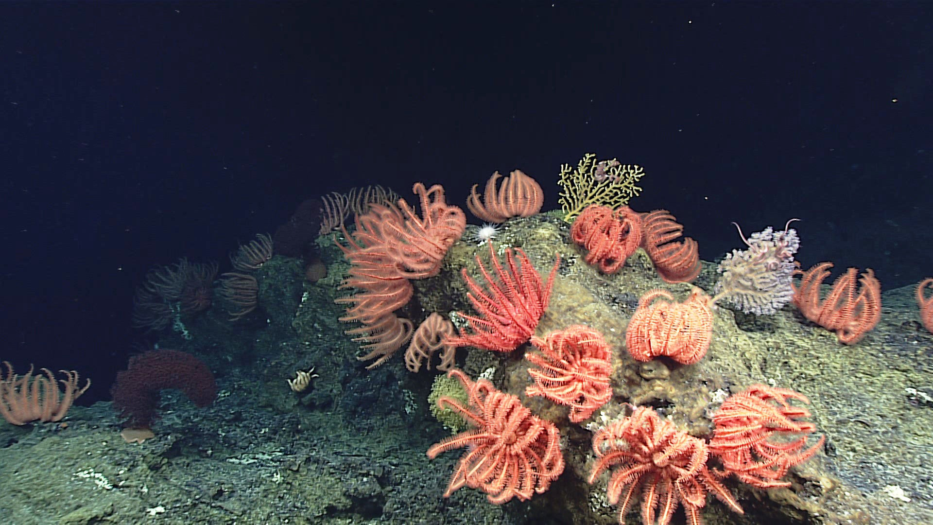
Download largest version (jpg, 972 KB).
In 2024, NOAA Ocean Exploration conducted three expeditions on Okeanos Explorer within Papahānaumokuākea, mapping 36,685 square kilometers (52,774 square miles), thereby increasing the region’s modern mapping coverage by approximately 9%. The collected mapping data will help increase understanding of marine life and habitats to inform management decisions, help to establish a baseline assessment of the ocean environment, and increase public awareness of ocean issues. These data will also be instrumental in informing future exploration efforts, including those being conducted during the Beyond the Blue: Papahānaumokuākea ROV and Mapping expedition.
Expedition Operations
During the Beyond the Blue: Papahānaumokuākea ROV and Mapping expedition, the team will work to further fill gaps in our understanding of the region by conducting focused mapping and ROV operations, with a focus on waters deeper than 200 meters (656 feet) within the region.
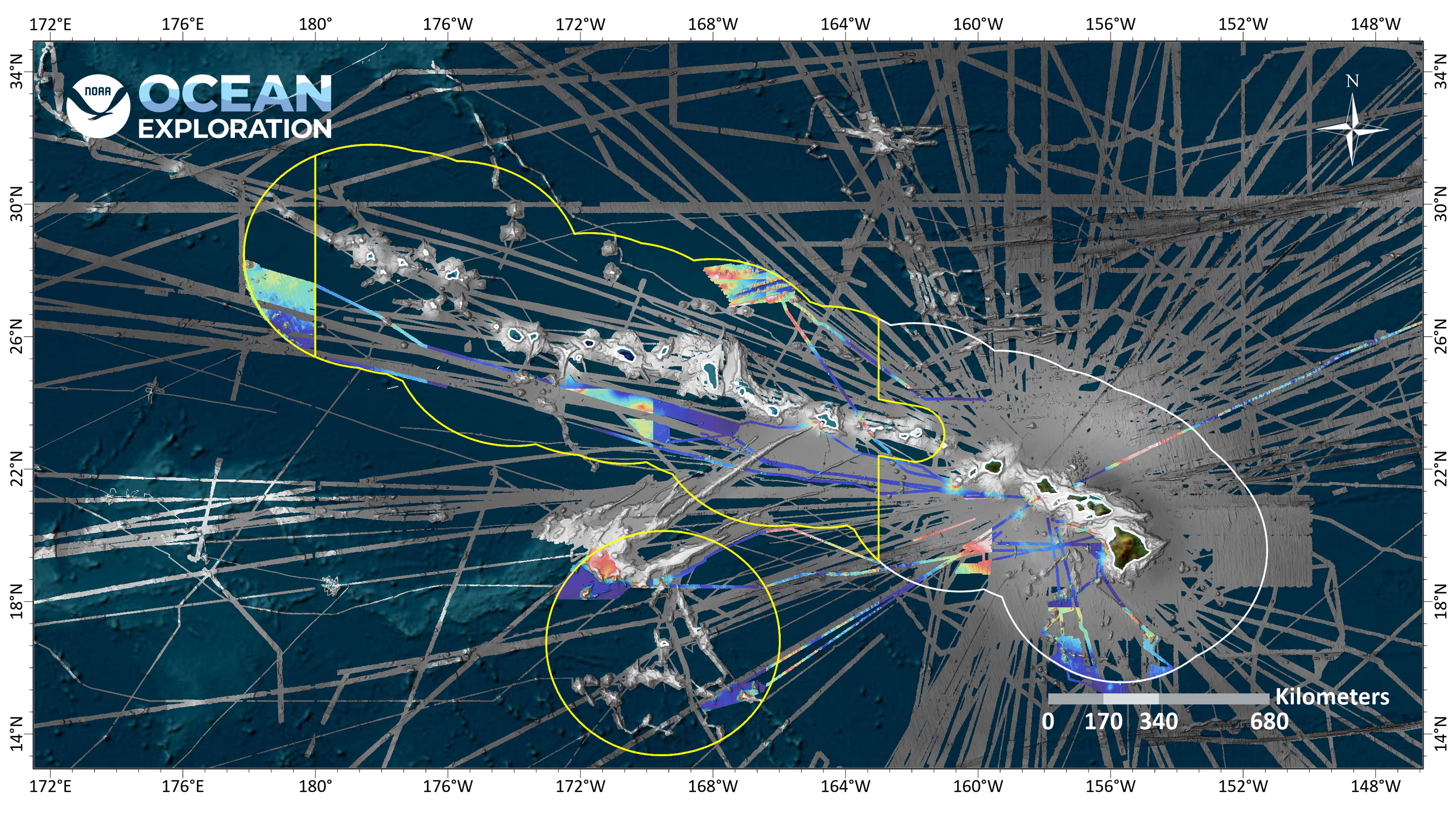
Download largest version (jpg 3.71 MB).
Mapping operations will build off of work conducted in 2024 and serve as the basis for planning and executing ROV dives during the expedition. Given the sparsity of mapping data in the region, in some instances, the team will follow a “map and dive” approach, collecting mapping data the night before a dive to guide the path of the ROV on a dive taking place the following morning.
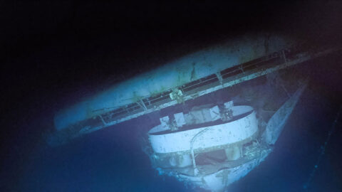
Over the course of the expedition, we will conduct ROV dives to explore deep-sea coral and sponge habitats, seamounts, maritime heritage sites, and the water column. Thanks to telepresence technology, anyone with an internet connection is invited to watch and listen as members of the science community actively engage and guide each dive.
All things permitting, when the ship is not in transit, dives will be streamed most days, April 11 to May 2, from approximately 7 a.m. to 5 p.m. HDT / 1 p.m. to 11 p.m. EDT. Note that dates and times are subject to change.
All data collected during the expedition will contribute to Beyond the Blue: Illuminating the Pacific, a multifaceted science campaign designed to increase knowledge about deep ocean waters in the Pacific Islands region. The campaign directly supports National Strategy for Ocean Mapping, Exploration, and Characterization (NOMEC) goals to close gaps in understanding of a region critical to U.S. national security, fisheries, mineral and energy resources, and biodiversity.
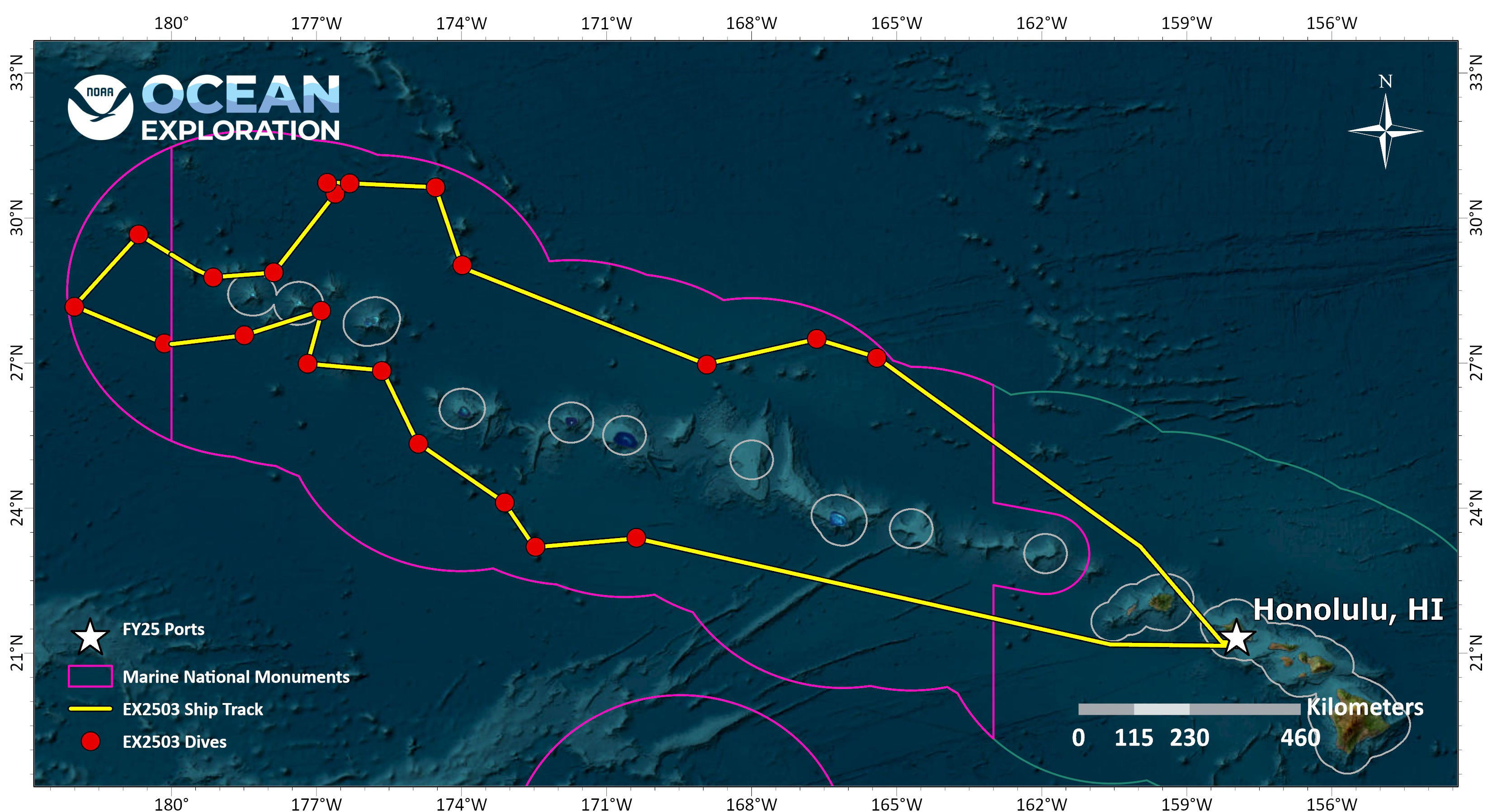
Download largest version (jpg 1.97 MB).
Live Track/Current Position Map
Map data courtesy of NOAA’s National Centers for Environmental Information (NCEI).
Features

Multimedia
Featured multimedia assets associated with this project.
Dive Summary Map
The map below shows the location of dives during the expedition. Click on a dive number to access the update from that day.
Education
Our Learn & Discover page provides the best of what the NOAA Ocean Exploration website has to offer to support educators in the classroom during this expedition. Each theme page includes expedition features, lessons, multimedia, career information, and associated past expeditions. Below are related top education themes for this expedition.
Meet the Exploration Team
Learn more about the team members and their contributions to this project.


Resources & Contacts
-
Emily Crum
Communication Specialist
NOAA Ocean Exploration
ocean-explore-comms@noaa.gov -
Keeley Belva
Public Affairs Officer
NOAA Office of Marine and Aviation Operations
keeley.belva@noaa.gov -
Jennifer Crawford
Pacific Islands Region Communications Coordinator
NOAA Office of National Marine Sanctuaries
jennifer.crawford@noaa.gov